![]()
![]()
La storia delle opere idrauliche,generalmente associata alla civiltà greco-romana,ricca di grandi acquedotti,risale ad epoche molto più remote. Le tecniche dell’approvvigionamento idrico,sono state affrontate dalle più antiche culture, con sistemi, inizialmente molto semplici adeguati alle caratteristiche del territorio e dell’ambiente circostante, fino alla costruzione d’imponenti e complesse opere idrauliche.
The history of hydraulic structures, generally associated with the greek-Roman civilization, full of great aqueducts, dates back to very ancient times. The technical water supply, have been addressed from the most ancient cultures, systems, initially very simple tailored to the characteristics of the territory and the environment, until the construction of the imposing and complex hydraulic structures.
INDIA
Sringaverapura
Il sistema di decantazione dell’acqua, risalente alla fine del I secolo a.C., comprendeva tre cisterne di raccolta (da percolazione) e contenimento alimentate da un canale largo undici metri e profondo cinque metri che raccoglieva le acque del Gange,dopo le inondazioni causate dai monsoni.
L’acqua,dal canale, entrava prima in una camera dove il limo veniva depositato.Quest’acqua,relativamente pulita,era poi diretta alla prima cisterna rivestita di mattoni (cisterna A) poi nella seconda cisterna (cisterna B) attraverso un’ingresso dotato di scalino ( che serviva per pulire ulteriormente l’acqua).
Questa era la cisterna primaria per la fornitura d’acqua.
Successivamente, defluiva verso una vasca circolare (cisterna C) che aveva un sistema di scalini, un elaborato contenitore di rifiuti dotato di sette canali di versamento, una cresta, ed una uscita finale che assicurava, all’acqua in eccesso, di riversarsi nuovamente nel fiume Gange.
INDIA
Sringaverapura
The water decanting system, dating from the late first century BC, included three collection tanks (by percolation) and containment fed by a channel eleven meters deep and five meters which collected the waters of the Ganges, after floods caused by monsoons.
The water from the canal, entered first into a room where the limo was depositato. This water, relatively clean, was then directed to the first tank of bricks covered (tank A) then in the second tank (tank B) through an input with step (which was used to further clean the water).
This was the primary tank for the supply of water.
Subsequently, he drained towards a circular tank (tank-C) which had a system of stairs, an elaborate waste container equipped with seven payment channels, a ridge, and a final output that ensured, excess water, spilling again in Ganges River.
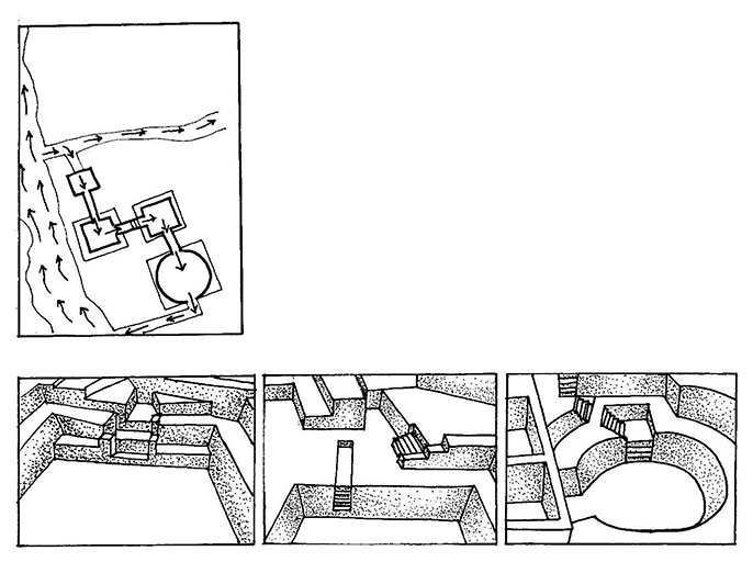
Rappresentazione grafica delle cisterne di decantazione del sistema idraulico di Sringaverapura (India I sec. a.C.)
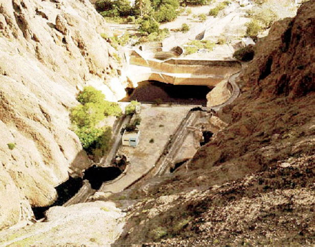
Burhanpur
Il periodo Moghul ha lasciato in tutta l’India, una grande eredità in fatto di acquedotti ben progettati. Un esempio tipico, è il vecchio acquedotto di Burhanpur sulla sponda del fiume Tapti in Madhya Pradesh.
Il progetto consisteva in ”bhandaras”, cisterne di contenimento che raccoglievano l’acqua del suolo dalle sorgenti sotterranee che scorrevano dalle colline adiacenti Saptura, verso il Tapti.
L’acqua del suolo era intercettata da quattro posizioni a nord-ovest di Burhanpur e confluiva, attraverso condotti sotterranei, fino ad una camera di giunzione chiamata ”jail karanj”. Qui, era immagazzinata l’acqua per l’approvvigionamento dell’intera città.
Il sistema è oggi abbandonato,ma i suoi condotti dell’aria,vengono usati come pozzi per attingere l’acqua.
Burhanpur
The Mughal period has left all over India, a great legacy in terms of well-designed aqueducts. A typical example is the old aqueduct in Burhanpur on the bank of the river Tapti in Madhya Pradesh.
The project consisted of ” Bhandaras ”, containment tanks that collected water the soil from underground springs that flowed from Saptura adjacent hills, toward the Tapti.
The soil water was intercepted by four positions to the north-west of Burhanpur and flowed through underground ducts, up to a junction called room ” jail karanj ”. Here, the water was stored for the supply of the entire city.
The system is now abandoned, but its air ducts, are used as wells to draw water.
Rappresentazione grafica dell’acquedotto di Burhanpur (India)
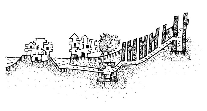
Khadin
Il khadin, è un’ingegnosa costruzione progettata per raccogliere ”la fuga dell’acqua” sulla superficie e viene utilizzata nell’agricoltura. La sua principale caratteristica,è una diga di terra molto lunga costruita attraverso i pendii più bassi della collina, al di sotto degli altopiani ghiaiosi.
Chiuse e sfioratori permettono, all’eccesso di acqua,di sgocciolare. Il sistema khadin,è basato sul principio di raccolta di acqua piovana su terreni agricoli ed il successivo impiego dell’acqua, proveniente dai terreni saturi, per la produzione di colture.
Questo sistema è molto simile al metodo d’irrigazione usato nella città di Ur (Iraq) intorno al 4500 a.C., successivamente dai Nabatei nel Medio Oriente e nel deserto del Negev.
Khadin
The khadin, is an ingenious construction designed to raise ” the water leakage ” on the surface and is used in agriculture. Its main feature is a long earthen dam built across the lower slopes of the hill, below the stony highlands.
Locks and spillways allow, excess water to drip. The khadin system, is based on the principle of collecting rainwater on agricultural land and the subsequent use of water, coming from the saturated ground, for the production of crops.
This system is very similar to the irrigation method used in the city of Ur (Iraq) around 4500 b.C. and subsequently by the Nabataeans in the Middle East and in the Negev desert.
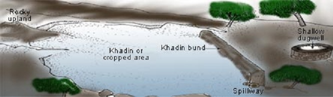
Rappresentazione grafica dell’ingegnoso sistema Khadin (India)
PAKISTAN
GABARBAND – Dighe Diwana nel sud del Belucistan dal periodo Amri-Nal
La civiltà dell’Indo è rinomata per le sue pratiche di gestione delle acque.
Secondo Louis Flam, l’ampia tecnologia di controllo delle acque della civiltà dell’Indo, iniziò nella regione durante il periodo Amri-Nal e si sviluppò in tre forme.
La prima è molto semplice e utilizza il naturale allagamento del ruscello collinare per irrigare i terreni ai lati del ”nai”con il minimo intervento umano.
Questa tecnica è simile a una forma di coltivazione ampiamente praticata sulle pianure alluvionali Indo conosciuta come ”sailabi”ed è stata vividamente documentata nel sito di Kahtras Buthi.
La seconda forma, documentata nel sito di Nal Bhuti, fa uso di piccoli fossati, poco profondi, per direzionare delicatamente acqua di sorgente su una zona pianeggiante che viene utilizzata per le coltivazioni.
Questo è un metodo d’irrigazione utile ed affidabile e, dal momento che le sorgenti sono attive tutto l’anno, è possibile avere un raccolto invernale di granaglie e un raccolto estivo di altre coltivazioni.
La terza forma d’irrigazione è documentata nel sito di Nuka e consiste nella formazione di un involucro protettivo o un muro di terra basso conosciuto localmente come un ”kach”o un ”gabarband”.
Qui, il terreno alluvionale è stato accumulato dietro basse dighe previste attraverso il drenaggio in pendenza, per creare una riserva d’acqua.
Un tipico esempio è il gabarband del sito di Diana sul fiume Hab, dove le acque sono state, presumibilmente, accumulate in un bacino di raccolta e rilasciate lentamente verso i campi.
Il sistema dei gabarband è originario del Belucistan e risale al periodo degli insediamenti Nal ed è ancora oggi in uso.
Fondamentalmente il Belucistan meridionale produce un raccolto di grano all’anno ed è soprattutto un ”khushkhaba” o coltura a pioggia.
La pendenza del Belucistan meridionale è, generalmente, da nord a sud tranne i suoi margini orientali dove, i flussi locali (Mula, Kulach) sfociano dentro Sindh attraverso passaggi nell’area del Kirthan.
I pricipali fiumi scorrono verso sud e passano attraverso le valli dove gli insediamenti sono più concentrati.
PAKISTAN
GABARBAND – The Diwana Dam in southern Balochistan by period Amri-Nal
The Indus civilization is renowned for its water management practices.
According to Louis Flam, the wide waters of the Indus civilization control technology, began in the region during the Amri Nal-period and developed in three forms.
The first is very simple and uses the natural flooding of the hillside brook to irrigate the land on either side of the ” nai”with a minimal human intervention.
This technique is similar to a form of cultivation widely practiced on Indus flood plains known as ” sailabi”and was vividly documented in the Kahtras Buthi site.
The second form, documented in Nal Bhuti site, makes use of small ditches, shallow, gently to direct source of water on a flat area that is used for the crops.
This is a useful and reliable irrigation method, since the sources are active throughout the year, you can have a winter crop of corn and a summer harvest of other crops.
The third form of irrigation is documented in Nuka site and consists in the formation of a protective casing or a low earth wall locally known as a ” kach”o a ” gabarband ”.
Here, the alluvial soil has accumulated behind low dams provided through the drainage on slopes, to create a water reservoir.
A typical example is the gabarband of Diana site on the Hab river, where the waters were presumably accumulated in a reservoir and slowly release to the camps.
The gabarband system is originally from Balochistan and dates back to the period of Nal settlements and is still in use today.
Basically the southern Balochistan produces a crop of wheat a year and is above all a ” khushkhaba” or crop to rain.
The slope of the southern Balochistan is generally from north to south but its eastern edge where, local flows (Mula, Kulach) in Sindh flow through passages in the Kirthan.
The main rivers flow south and go through the valleys where settlements are more concentrated.
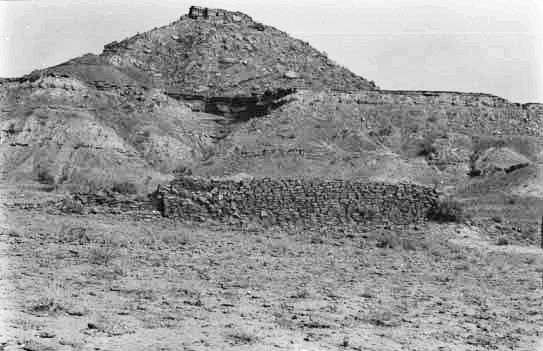
Gabarband composto da un basso muro di terra
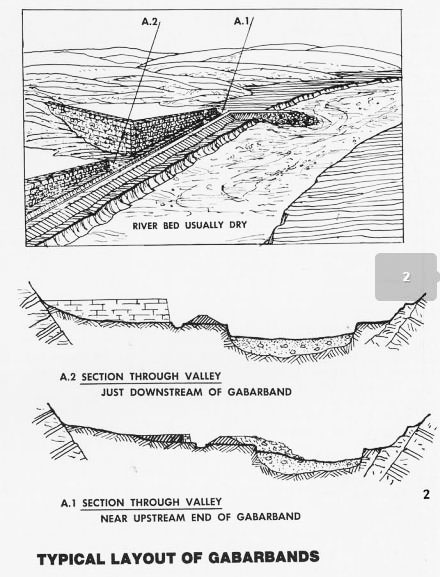
Rappresentazione di un gabarband – Sezione
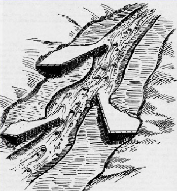
Rappresentazione di un gabarband sul fiume
IRAN
Shushtar – Mulini ad acqua
Shushtar era un’antica cittadella fortificata della Persia. Il suo sistema idrico,era un’insieme di strutture che rifornivano d’acqua la città già al tempo di Dario il Grande nel V secolo a.C. Questo sistema,era composto da due canali che estraevano l’acqua dal fiume Karun.
L’altro canale, il Gargan, ancora oggi viene utilizzato per portare l’acqua alla città. I condotti sotterranei, portano acqua ai mulini della zona. Il canale raggiunge la città da sud e fornisce d’acqua una grande zona coltivata ad orchidee.
La spettacolare cascata,cade dalla scogliera e si riversa verso le ampie zone di raccolta. Di questo complesso né fanno parte il Salasel Castle, il centro operativo del sistema idraulico, le torre di misurazione del livello dell’acqua, dighe, ponti, bacini e mulini.
Shushtar è la testimonianza dell’eredità lasciata dagli Elamiti e Mesopotami, abili maestri e dell’influenza che hanno avuto i Nabatei con la costruzione dell’ingegnoso sistena idrico di Petra.
IRAN
Shushtar – Water mills
Shushtar was an ancient fortified citadel of Persia. Its water system, was a set of structures that supplied water to the city since the time of Darius the Great in the fifth century b.C. This system consisted of two channels that extracted the water from the river Karun.
The other channel, the Gargan, still is used to bring water to the city. The underground conduits, bring water to the mills of the area. The channel reaches the city from the south and provides water a large area planted with orchids.
The spectacular waterfall, falls from the cliff and pours into the large collection areas. They are part of this complex nor the Salasel Castle, the center of operations of the hydraulic system, the measurement tower of the water level, dams, bridges, basins and mills.
Shushtar is the legacy left by the testimony Elamites and Mesopotamians, skilled masters and the influence they have had the Nabataeans with the construction of the ingenious water system of Petra.
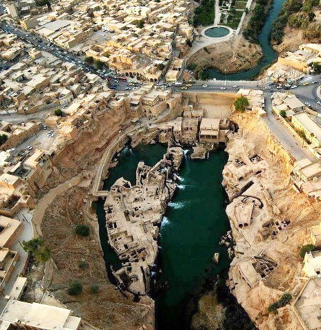
Sistema idrico di Shushtar (Iran)
GIORDANIA
Petra
L’area archeologica della città,è una delle più estese al mondo. I gruppi locali di beduini,hanno utilizzato un sistema vecchio di 2500 anni,costruito dai Nabatei. Questo ingegnoso popolo,era riuscito a captare tutte le acque che scorrevano sulle montagne durante le scarse piogge ed a convogliarle in un articolato sistema di cisterne.
Nel tempo, le popolazioni del luogo, hanno utilizzato questo complesso sistema, continuando ad abitare le grotte, proprio grazie alla capacità di utilizzare le risorse della zona, raccogliendo e conservando l’acqua.
La profonda spaccatura chiamata siq, era il percorso delle acque del Wadi Musa che attraversava la grande città monumentale scolpita nella rosata arenaria.
I Nabatei costruirono un sistema capillare per la raccolta dell’acqua che, lungo le pareti,seminascosto tra le grandi architetture megalitiche, è ancora possibile riscontrare; una rete di ampie dimensioni composta da tubature, canali di scolo e cisterne.
Ancora oggi, dalle gole scoscese di arenaria rosa,gocciola l’acqua che viene raccolta in numerose vasche scavate nella roccia chiamate ”qottara”.
Queste cisterne, erano utilizzate dai Nabatei e dai popoli che si sono succeduti nel tempo, per il quotidiano fabbisogno di acqua.
I beduini hanno continuato ad abitare le grotte di Petra fino agli anni ’80, periodo in cui gli abitanti sono stati trasferiti per la tutela del sito archeologico.
GIORDAN
Petra
The archaeological area of the city, is one of the largest in the world. Local groups of bedouins, who used an old 2500 years old system, built by the Nabateans. This ingenious people, had managed to capture all the water flowing in the mountains during the low rainfall and channel them in a structured system of cisterns.
Over time, the local populations, have been using this complex system, continuing to inhabit the caves, thanks to the ability to use the resources of the area, collecting and conserving water.
The deep rift called siq, was the path of the Wadi Musa waters that crossed the great monumental city carved into rose-red sandstone.
The Nabataeans built an extensive system to collect water that, along the walls, hidden among the great megalithic architecture, it is still possible to find; a network of large dimensions composed of pipes, drains and tanks
Even today, with steep gorges of pink sandstone, dripping water which is collected in numerous pools carved into the rock called ” qottara ”.
These tanks, were used by the Nabateans and peoples that have followed over time, for the daily water requirements.
The bedouins have continued to inhabit the caves of Petra until the 80, a period in which the inhabitants were transferred to the protection of the archaeological site.
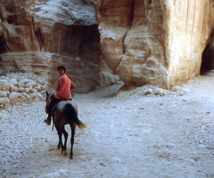
Petra – Percorrendo il Siq a cavallo, si arriva al tempio El Kasneck
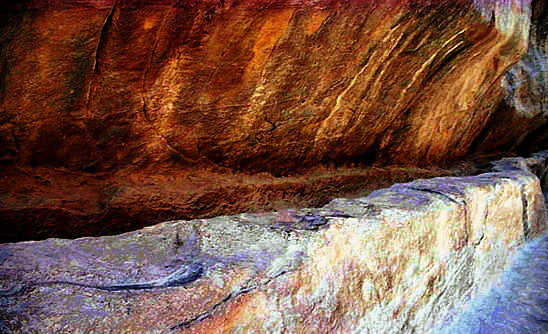
Petra – Sistema idraulico formato da canali scavati nella roccia
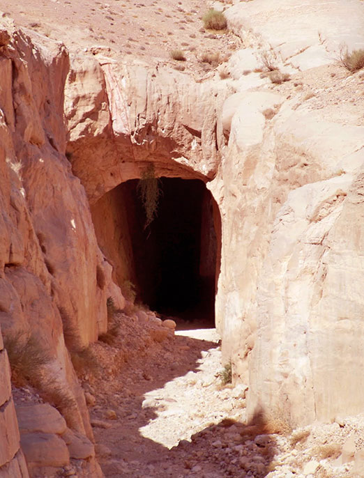
Tunnel chiamati siq, scavati dai Nabatei per deviare l’acqua, attraverso il canyon, verso l’ingresso della città
ALGERIA
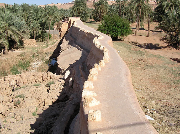
Diga di Beni Isguen Valle del M’Zab
Lungo la valle dell’oued M’Zab, il corso superficiale è completamente assente.
In questa zona sorgono, tra il X e l’XI secolo,cinque città circondate da mura e affacciate sul grande palmeto che prospera grazie alla costruzione di dighe interrate che sbarrano i flussi d’acqua sotterranei.
Nasce così,un’estesa oasi con notevoli caratteristiche urbane.
La diga di Beni Isguen, conserva le acque d’inferoflusso e delle sporadiche piene dello oued M’Zab. Attinte per mezzo di pozzi,queste acque alimentano i canali d’irrigazione dei giardini.
ALGERIA
Dam of Beni Isguen M’Zab Valley
Along the valley of the Oued M’Zab, the surface course is completely absent.
In this area arise, between the X and XI centuries, five cities are surrounded by walls and overlooking the largest palm grove that thrives thanks to the construction of underground dams barring underground water flows.
Thus it was born, an extensive urban oasis with remarkable features.
The dam of Beni Isguen, retains the waters of inferoflusso and sporadic floods of Oued M’Zab. Drawn through wells, these waters feed the irrigation canals of the gardens.
Diga di Beni Isguen (Algeria)
Le oasi dell’oued Saoura, formano un sistema lineare lungo l’alveo del fiume fossile, dai cui sedimenti traggono l’acqua con dighe che sbarrano il flusso sotterraneo. Le acque dell’Atlante, fluiscono nel grande Erg Occidentale e alimentano la falda al di sotto delle sabbie.
L’oued Saoura ha mantenuto libero il suo corso fino alla depressione del Touat.
Sbarramenti lungo il corso dell’oued, bloccano il flusso sotterraneo e permettono di drenare l’acqua dei sedimenti con canalizzazioni che irrigano i terrazzamenti ai bordi dell’alveo.
A sud del Saoura, la falda si abbassa e l’acqua viene attinta tramite grandi pozzi a bilanciere ai margini del corso del fiume fossile.
La serie dei grandi pozzi, marca il paesaggio.
The oasis of Oued Saoura, form a linear system along the bed of the fossil river, from which sediment draw water with dams that bar the underground stream. The Atlas waters, flowing into the large Western Erg and feed the water table beneath the sands.
The wadi Saoura kept free run its course until the depression of Touat.
Weirs along the course of Oued, block the underground flow and allow to drain water of sediments with channels that irrigate the terraces at the edge of the riverbed.
South of the Sahara, the water table is lowered and water is drawn through large rocker shafts at the edge of the course of the fossil river.
The series of large pits, marks the landscape.
Ricostruzione delle dighe di sbarramento lungo l’oued (Disegno di Natalia Tarabella modificato da disegno di Pietro Laureano)
Khottara, grande pozzo a bilanciere (Shaduf)
YEMEN
L’ANTICA DIGA DI MARIB (Yemen)
Diecimila anni fa, nello Yemen centrale, esisteva un sistema fluviale integrato. Gli wadi Al Jawf, Dhana, Baylan e Markha, confluivano nel wadi Hadramaut.
La vegetazione di queste valli, era da savana,molto scarsa e popolata di fauna. Nella zona ci sono molte pitture rupestri che riproducono queste figure di animali. La popolazione era di cacciatori-raccoglitori e,quindi, non era necessaria l’irrigazione dei terreni.
Nel IV millenio a.C. il clima cambiò; diventò più secco, diminuì l’acqua dei fiumi e si diradò la vegetazione.
Le popolazioni avevano bisogno di un’alternativa e cominciò, così, l’era dell’agricoltura nelle zone marginali degli wadi dove il terreno era reso più fertile dal tracimare del corso dei fiumi. Si passò, poi, alla costruzione di semplici dighe di terra per portare più acqua nei campi. Attraverso questo tipo d’irrigazione, arrivavano sedimenti freschi che fertilizzavano il terreno.
A Marib, per trattenere l’eccedenza d’acqua della piena,si costruirono piccoli muretti sulla roccia basaltica. Le sostanze trasportate dall’acqua, sedimentavano formando terra fertile per l’agricoltura. Dall’esame dei sedimenti, si può datare l’inizio dell’irrigazione a Marib nel III millenio a.C. e più a sud, forse, anche prima.
Inizialmente l’irrigazione artificiale e la costruzione di dighe, cominciò lungo gli wadi minori con semplici dighe di terra e divisori per l’acqua costruiti con pietre. Da queste semplici dighe,si sviluppò una più complessa tecnica che riusciva a convogliare anche l’acqua delle grandi piene della valle principale.
Per evitare che i campi venissero insabbiati dal vento del deserto,l’irrigazione si spostò nella zona centrale della valle,più protetta dai venti.
Si arrivò, così, al passaggio da un’irrigazione di piccola portata a quella che, in età classica, copriva grandi superfici. Intorno all’inizio del III millennio a.C. sugli altopiani dell’area di Dhamar, ci fu un cambiamento climatico che portò alla diminuzione del regime delle piogge.
Gli insediamenti umani iniziarono ad avere un’importante impatto ambientale.
La pratica dell’agricoltura si diffuse in tutti gli altopiani e la deforestazione servì per creare la costruzione di terrazzamenti a scopo agricolo. La diminuzione del manto vegetale,favorì il cambio della portata d’acqua dei fiumi che,da corsi d’acqua perenni,divennero torrenti portatori di piene stagionali. I torrenti trasportavano sedimenti che fertilizzavano il suolo,ma le piene doveveno essere controllate.
I canali scavati rinvenuti nella zona di Malayba,sono stati datati all’Età del Bronzo. La pratica dell’irrigazione era già diffusa prima che i Sabei costruissero le grandi dighe di Marib. Dall’esame dei canali è possibile pensare che esistesse un sistema vasto e misto che sfruttava sia un corso d’acqua perenne, sia le piene portatrici di sedimenti fertili.
Gli scavi testimoniano, inoltre, una diminuzione dell’ampiezza dei canali dovuta,probabilmente,alla mancanza di acqua perenne disponibile. Questo fu il motivo dell’abbandono del sistema.
YEMEN
ANCIENT DAM OF MARIB (Yemen)
Ten thousand years ago, in central Yemen, there was a built-river system. The wadi Al Jawf, Dhana, Baylan and Markha, flowed into the wadi Hadramaut.
The vegetation of these valleys, was savannah, very poor and populated with wildlife. In the area there are many cave paintings that reproduce these figures of animals. The people were hunter-gatherers, and thus it was not necessary to irrigate the land.
In the fourth millennium b.C. the climate changed; became drier, he decreased the water of the rivers and cleared vegetation.
The people were in need of an alternative and started, well, the era of agriculture in marginal areas of the wadi where the ground was made fertile by the overflow of the rivers. He passed, then, to the construction of simple earthen dams to bring more water to the fields. Through this type of irrigation, coming fresh sediments that fertilizing the soil.
In Marib, to retain the excess of the full water, small stone walls were built on basalt rock. Substances carried by water, formed fertile land for agriculture. An examination of the sediments, you can date the beginning of irrigation in Marib in the III millennium b.C. and further south, perhaps even earlier.
Initially, the artificial irrigation and the construction of dams, began along the wadi children with simple earth dams and partitions for the water built with stones. From these simple dams, he developed a more complex technique that could also carry the water of the great flood of the main valley.
To avoid that the fields were covered up by the desert wind, irrigation shifted in the central valley, more protected from the wind.
He came, so, at the transition from small-scale irrigation to what, in the classical age, covering large areas. Around the beginning of the III millennium b.C. the highlands area of Dhamar, there was a climate change that led to the decrease in the rainfall regime.
Human settlements began to have an important environmental impact.
The practice of agriculture spread throughout the highlands and deforestation was used to create the building of terraces for farming. The reduction of vegetation cover, favored the return of the water flow of the rivers, from perennial streams, streams became bearers of seasonal floods. The streams transported sediments that fertilizing the soil, but floods had to be controlled.
Dug canals found in the area of Malayba, they have been dated to the Bronze Age. The practice of irrigation was already widespread before the Sabeans they built large dams Marib. An examination of the channels is possible to think that there was a vast and mixed system which used to be a perennial stream, both the full bearers of fertile sediments.
The excavations testify, moreover, a decrease in the amplitude of the channels due, probably, to the lack of available perennial water. This was the reason of the abandonment of the system.
Ricostruzione dell’antica oasi di Marib – Diga (H.David)
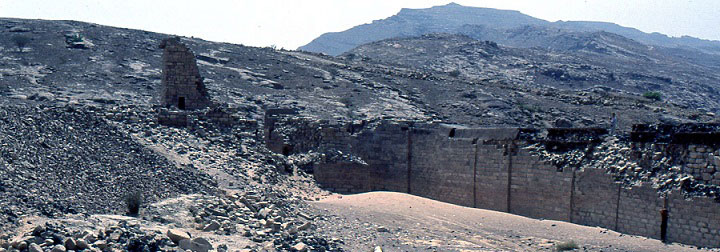
Marib – Chiusa nord della diga
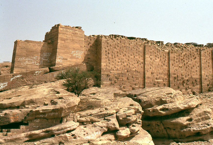
Marib- Chiusa sud della diga
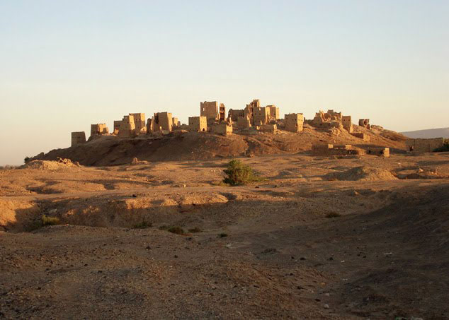
Acropoli di Marib
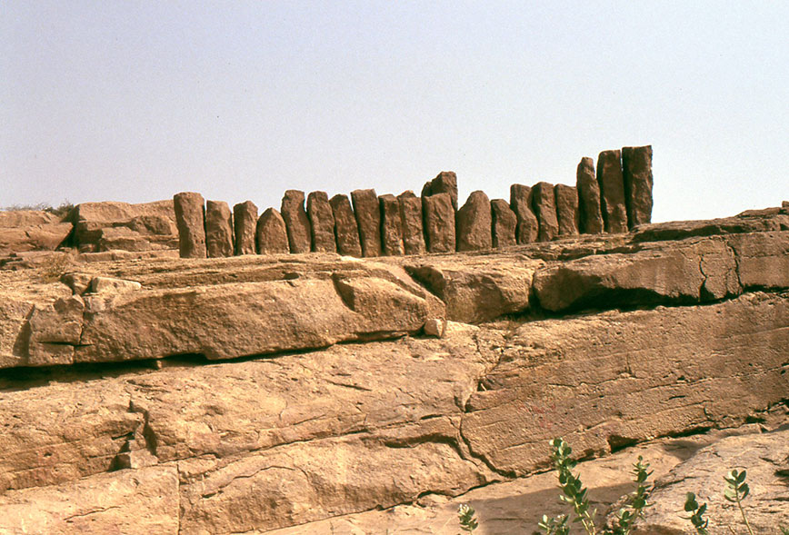
Marib – Misuratori
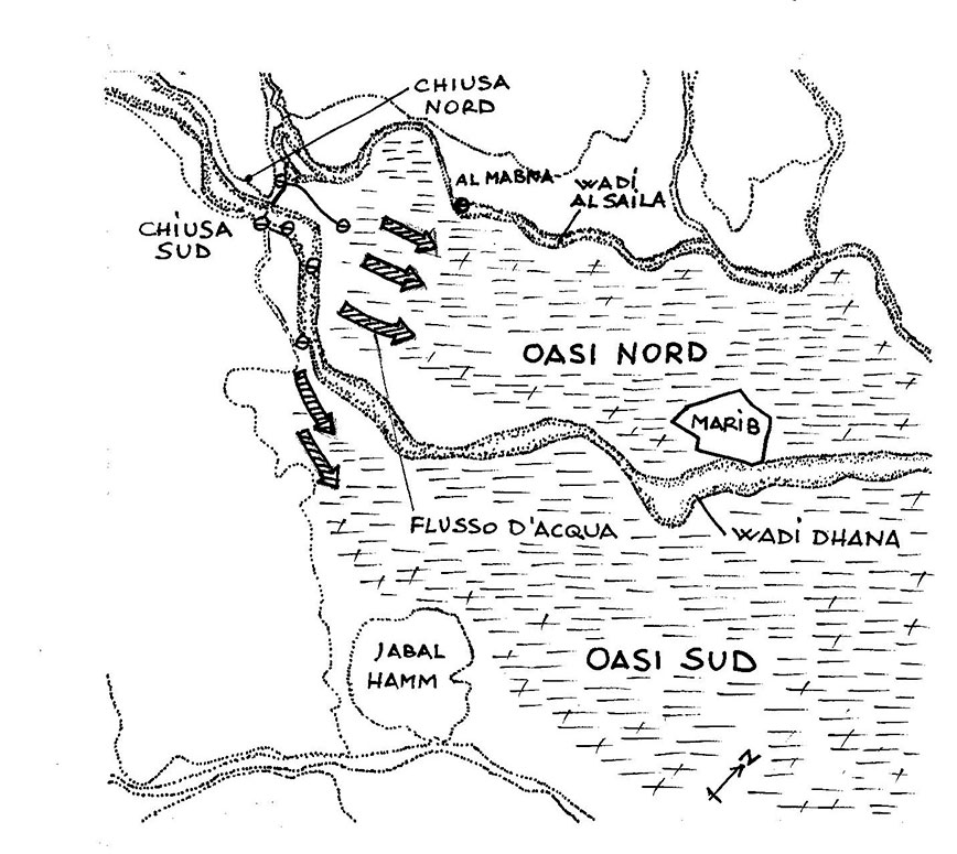
L’OASI DI MARIB
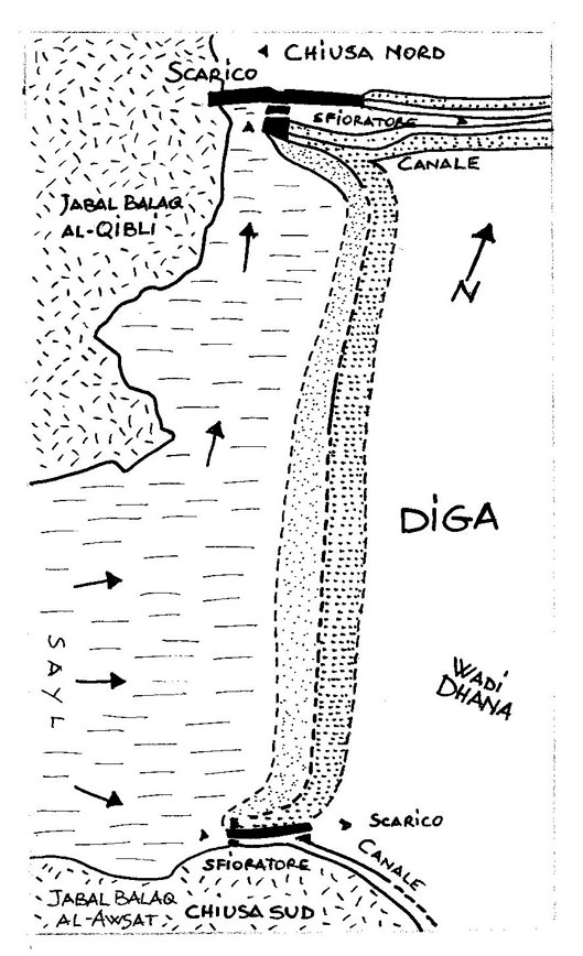
L’oasi di Marib era alimentata dal sayl del wadi Dhana. Le sue acque defluivano dall’altopiano verso il deserto. All’uscita del wadi Dhana dalla gola dei monti Balaq,la valle venne sbarrata con una diga di terra lunga 680 metri.
Questa diga serviva per innalzare l’acqua fino al livello dei campi e irrigare, così,l’intera Marib.
A sud ed a nord della diga, venne costruito,sulla roccia calcarea,un canale di scarico murato. La quantità d’acqua necessaria per alimentare il sistema dei canali, era garantita da questo sfioratore. Un canale primario portava l’acqua dalle chiuse alle zone da irrigare.Da qui,un distributore principale,alimentava il sistema di canali con le acque raccolte.I campi venivano irrigati da canali collettori in muratura,oppure tramite sfioratori in terrapieni,passando l’acqua da un campo all’altro.
L’acqua in eccesso, rientrava nello wadi situato più in basso. Le piene garantivano l’irrigazione di Marib;i campi venivano allagati e l’acqua filtrava nel limo lasciando che le sostanze fertili si depositassero. Nei periodi di siccità, le piante come le palme da dattero, venivano irrigate con l’acqua dei pozzi.
L’oasi era divisa da due giardini sui due lati del wadi Dhana. Questo metodo d’irrigazione Sabea fu mantenuto per molti secoli e la ragione della sua lunga durata,fu la semplicità del sistema e la capacità di gestire le grandi piene che si verificavano periodicamente.
DUE OASI DETTE ” DUE PARADISI”.
Marib ed i ”due giardini” di Saba.
Dal Corano ” XXXIV la sura dei Saba – Invero la gente di Saba’ ebbero nella lor dimora un Segno : due giardini,a destra e a sinistra. Mangiate,dicemmo loro,della provvidenza del vostro Signore e rendeteGli grazie; una buona terra avete e un Signore indulgente”.
OASIS OF MARIB
The oasis of Marib was fueled by sayl Wadi Dhana. Its waters desflurane from the plateau to the desert. The output of the Wadi Dhana from the throat of the mountains, the valley was crossed out with a long 680 meters of earth dam.
This dam was used to raise the water to the level of the fields and irrigation, as well, the entire Marib.
To the south and north of the dam, it was built on limestone, a walled spillway. The amount of water needed to power the system of channels, was guaranteed by this spillway. A primary channel carried water from closed areas to irrigare.From here, a main distributor, fed the system of canals with the water collected. The fields were irrigated by canals masonry collectors, or through spillways in earthworks, passing the ‘ water from field to field.
The excess water, fell in the wadi located further down. The full guaranteed irrigation of Marib; the fields were flooded and the filtered water in the silt letting the fertile substances. In periods of drought, plants such as date palms, were irrigated with water from wells.
The oasis was divided by two gardens on either side of the wadi Dhana. This irrigation method Sabea was maintained for many centuries, and the reason of his long life, was the simplicity of the system and the ability to handle major floods occurred periodically.
OASIS TWO SAID ” TWO PARADISE”
Marib and ” two ” gardens of Sheba.
From the Koran ‘‘ XXXIV Sura of Saba – Saba Indeed the people ‘were in their home a Sign: two gardens on the right and left. Eat, we told them, the providence of your God and repay Him thanks; you have a good ground and a forgiving God ‘‘.
Ricostruzione del particolare delle due chiuse della diga di Marib (U.Brunner)
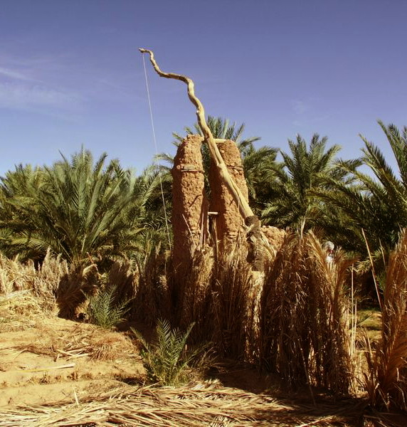
Le cisterne di Aden
Le cisterne preislamiche di Aden, chiamate della regina di Saba, servivano per l’approvvigionamento idrico e per proteggere, dall’acqua alta,l’antica città portuale di Aden situata allo sbocco del cratere vulcanico.
L’acqua raccolta nel cono vulcanico,era immagazzinata in una serie di profonde cisterne. In passato, il cratere, era impermeabilizzato e funzionava come un’ampio dispositivo di captazione dell’umidità che alimentava le vasche di raccolta.
The cisterns of Aden
The pre-Islamic cisterns of Aden, called the Queen of Sheba, were used for the water supply and to protect, high water, the ancient port city of Aden, situated at the mouth of the volcanic crater.
The water collected in the volcanic cone, was stored in a series of deep tanks. In the past, the crater, was waterproofed and worked as an ample moisture uptake device that fed the collection tanks.
Le cisterne di Aden collocate sul cratere del vulcano
SOCIETA’ PRECOLOMBIANE
MESSICO
Collina di Tetzcotzingo – Atzeca
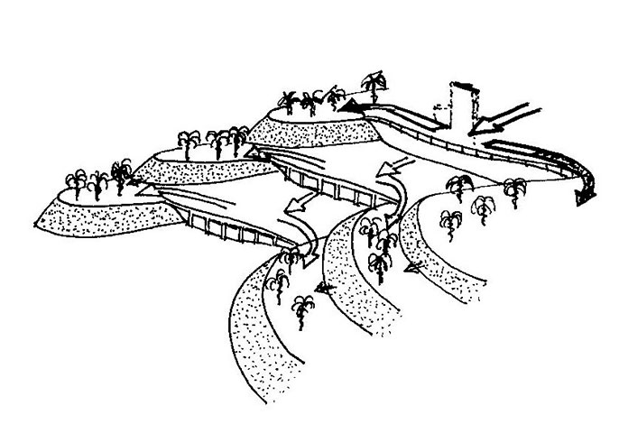
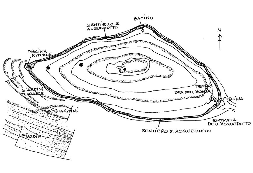
Situata sulle pendici del monte Tlaloc, a est di Tetzcoco, questa collina è un grande sito archeologico circondato da terreni agricoli a terrazze. E’ uno straordinario luogo per i riti della pioggia dato che questi monti,grazie alle loro sorgenti e alle nuvole cariche di pioggia che si addensano intorno alle loro vette,sono le fonti d’acqua primarie per l’Acolhuacan centrale.
Tetzcotzingo e il monte Tlaloc svelano il ruolo religioso essenziale dei sovrani aztechi in quanto responsabili della caduta della pioggia e del passaggio dalla stagione secca a quella umida. Nel recinto sacro,sopra la foresta, i sovrani entravano nel luogo di contatto tra cielo e terra, facevano delle offerte e tornavano a casa come portatori dell’acqua, donatrice di vita.
I templi sacri, sono racchiusi dal sentiero che corre parallelo all’acquedotto e nel sito sono presenti piscine rituali e un bacino.
PRE- COLUMBIAN SOCIETY
MEXICO
Hill of Tetzcotzingo – Aztec
Located on the slopes of Mount Tlaloc, east of Tetzcoco, this hill is a large archeological site surrounded by terraced farmland. It is an extraordinary place for rain rites as these mountains, thanks to their sources and rain clouds that are gathering around their peaks, are the primary sources of water for Central Acolhuacan.
Tetzcotzingo and Mount Tlaloc reveal the essential religious role of the Aztec rulers as responsible for the fall of rain and the transition from dry season to the wet season. In the sacred enclosure, above the forest, the sovereigns entered the place of contact between heaven and earth, made of the offers and returned home as water carriers, life-giving.
The sacred temples, are enclosed by the path that runs parallel to the aqueduct and on the site there are rituals pools and a basin.
Ricostruzione della zona sacra atzeca sulla collina di Tetzocotzinco
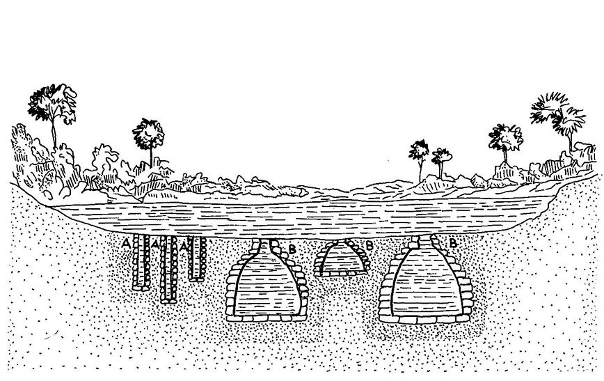
TECNOLOGIA IDRAULICA MAYA
A) Nel periodo preclassico gli insediamenti sono realizzati a valle dentro depressioni naturali utilizzate come riserve d’acqua.
B) Nel tardo periodo classico, la tecnologia idraulica permette di costruire nei luoghi elevati utilizzando la città con i suoi tetti e monumenti come captatori di acqua che alimentano una grande riserva centrale.
HYDRAULIC TECHNOLOGY MAYA
A) In the pre-classical period, the settlements are made downstream in natural depressions used as water reserves.
B) In the late classical period, the hydraulic technology allows you to build in high places using the city with its roofs and monuments such as water sensors that feed a large central reserve.

Ricostruzione della tecnologia idraulica Maya A) Periodo pre classico – B) Tardo periodo classico
Palenque
E’ una struttura idraulica scavata nella città Maya di Palenque (acquedotto di Piedras Bolos). E’ lunga circa sessanta metri ed ha una pendenza di sei metri.
L’acqua scorre lungo la rampa e finisce contro una barriera dove,costretta a passare attraverso un tubo molto stretto,produce un’alta pressione.
Palenque
It ‘a hydraulic structure carved into the Maya city of Palenque (aqueduct of Piedras Bolos). It is about sixty meters long and has a slope of six meters.
The water flows down the ramp and made against a barrier where, forced to pass through a very narrow tube, produces a high pressure.
Ricostruzione della struttura idraulica di Palenque
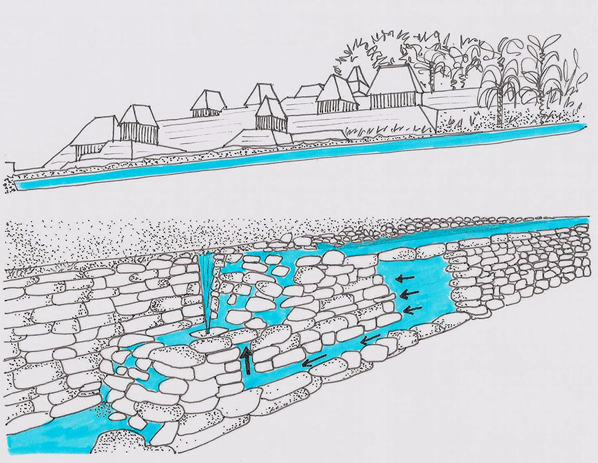
Aguada Maya – Yucatan
Sistema Maya per incanalare l’acqua pluviale raccolta dalle coperture degli edifici, dalle piazze e dalle vie della città.
Utilizzando la forza di gravità, l’acqua scorre e attraverso delle canalizzazioni, finisce in depositi situati nella zona.
Con i pozzi (A) ed i chultun (B) si conserva l’acqua quando l’aguada (C) diviene secca.
Aguada Maya – Yucatan
Maya system to channel the rain water collected from the roofs of buildings, the squares and the streets of the city.
Using gravity, water flows and through the ducts, it ends in stores located in the area.
With wells (A) and chultun (B) conserves water when the aguada (C) becomes dry.
Ricostruzione dell’Aguada Maya A) Pozzi – B) Chultun – C) Aguada
Polder (Paesi Bassi)
Il territorio olandese è,per la maggior parte,situato al di sotto del livello del mare. Il polder è una zona prosciugata artificialmente mediante dighe e sistemi di drenaggio dell’acqua.
Gli abitanti avevano bisogno di terra per l’agricoltura e per i pascoli e già dal medioevo, vennero adottate queste tecniche idrauliche. Nel XVII secolo,venne perfezionata la tecnica per prosciugare i tratti di mare con l’introduzione di mulini a vento che sfruttavano la forza del vento per catturare l’acqua ed espellere, in mare, quella che rimaneva dentro le dighe.
Polder (Netherlands)
The territory of the Netherlands is, for the most part, situated below the sea level. The polder is an area drained artificially by dykes and drainage systems.
The inhabitants were in need of land for agriculture and grazing, and since the Middle Ages, were adopted these hydraulic techniques. In the XVII century, the technique was perfected for the drainage of the sea area with the introduction of windmills that exploited the power of the wind to catch the water and expel, at sea, that was left inside the dikes.
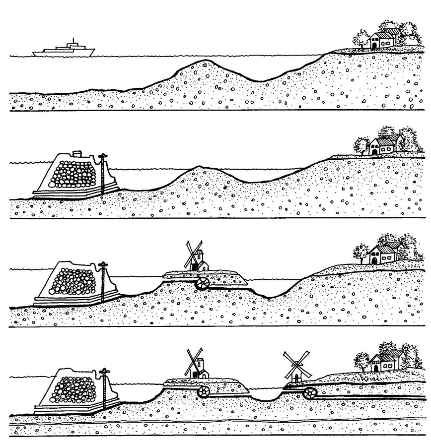
Ricostruzione del sistema Polder (Paesi Bassi)
